Tuesday, May 31, 2016

The Lupine Ride in Randolph and Jefferson 10:00 am

Thursday, June 2nd, 2016, 10:00 am

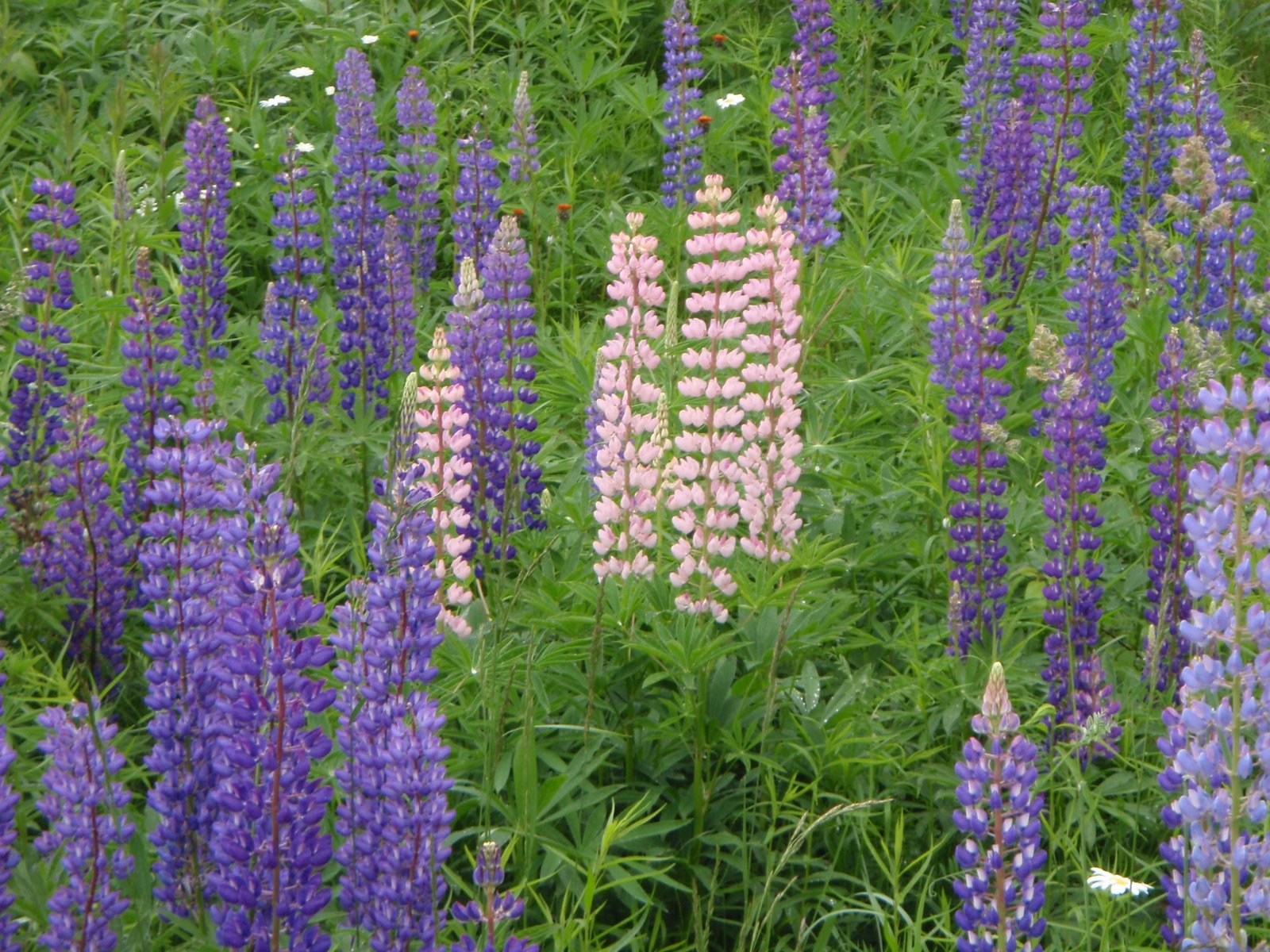
The Lupine:  Can be an amazing display!! They seem to be early this year, so I hope that they are ready for us!!

The Ride:  The route goes by some of the best displays of panoramic scenery and lupine fields in the area. The lupine photo that I have had on this blog and the photo on the MWV Bicycle Club website shows the stunning beauty of this area.

The ride includes the entire length of Valley Road, a hidden treasure, running in the valley parallel to Route 2 but without the traffic. Valley Road lacks pavement for about 2 miles. but the riding on it is usually fine - take your time and view the lupine! Durand Road is a terrific ride also, lined with summer houses from the 30's and their nice gardens and lupine along the roadside. 
The starts in Randolph on Pinkham B road at the intersection with the rail trail. We ride down Pinkham B to Route 2, cross Route 2 and enter Durand Road, a scenic quite road parallel to Route 2. At the end of Durand Road, we ride Route 2 for about 1.5 mile then turn left onto Valley Road. We ride Valley Road to Jefferson Meadows then up to the convenience store in Jefferson for lunch and snacks, then enjoy an amazingly scenic ride, Presidential views, back to our cars. 
You can ride a road, hybrid, touring, randonneur or mountain bike on this ride, all welcome. With wider tires you could use the Presidential Rail Trail for a part of the ride from the Castle Trailhead to Valley Road for something different. A road bike is OK too, (typically what everyone rides easily unless the road was graded on the day we ride...), pump up your tires and take it easy on the dirt. 


Start time: 10:00 am ready to ride at the parking lot on the west end of Pinkham B Road at the rail trail crossing.


Carpool: if you want to carpool, meet at the Jackson Ski Touring/Wentworth Golf Club parking area, across the street from the J-Town Deli at 9:10 am.


Ride length:  To Jefferson store for lunch stop and back, 32 miles


Directions to the start: The start is at the Randolph end of the Pinkham B Road. There is parking right next to where the Presidential Rail Trail crosses Pinkham B. Access Pinkham B road from the Dolly Copp Campground entrance off of Route 16. As you drive down the hill on Pinkham B and come out of the woods, the rail trail crosses the road at a public works department building. There is parking on the left side near the rail trail.


If you don't want to drive Pinkham B's adventurous dirt and "pavement", drive route 16 to Gorham, follow it towards Berlin and take a left on Route 2 at the traffic light. Go up the big hill and down the other side. Just after the hill flattens, Pinkham B Road will be on your left. Take the left and drive about 0.5 mile to the parking area near the rail trail on the right.


Wednesday, May 25, 2016

Apple Acres and Denmark Obelisk Ride

Apple Acres Orchard and Denmark Obelisk 10:00 am

Thursday, May 26th, 2016

Thursday looks like a great day for a bike ride!!

Dave and Connie created this ride a few years ago and everyone loved it!  It should be a beautiful ride this week, especially now that the pastures are emerald green and the apple trees are blooming (and the lilacs, too!).

Start the ride from the Brownfield Community Center, head to Route 160 via Pig Street, turn left on Tripptown Road, left on Durgintown Rd. Stop at Apple Acres for the view, the ice cream and the apple blossoms!!  Continue downhill and turn left on scenic River Rd to Hiram.  Take a right onto Route 117 and ride to the Obelisk in the center of Denmark. Take a left onto Route 160 and head back to the Community Center.


Ready to Ride at 10:00 am.

Distance is about 35 miles. 

Meet at the Brownfield Community Center, 10:00 am. To drive there from the Conway area, take Route 302 just over the border into Maine, take a right onto Haleytown Road to the stop sign, then left onto Hampshire. Bear left at the Y junction with Route 160, the community center will be a short distance on your right. 


Carpool if you like, from the back of Grant's parking lot, 9:00 am. 

For the map, check www.ridewithgps.com. The ride is called "Apple Acres and Denmark Obelisk Loop".

Tuesday, May 17, 2016

Crank Some Kanc 10:00 am

Thursday May 19th, 2016

Kranc Some Kanc

Another beautiful day is expected for this Thursday -- should be another great day for biking (if we can bike faster than the black flies can fly)!!

In honor of last Saturday's Kranc the Kanc event, let's Crank Some Kanc. How about the Sugar Hill Scenic Vista as the goal? It is a gradual uphill alongside the river, relatively flat after Rocky Gorge, then a short steep spot just before the Scenic Vista. It is a pleasant downhill back to the car via the Kanc, Passacnaway Road and Conway Village. There is very little traffic on the Kanc at this time of the year, let's enjoy it while it is all ours!  


Where to meet: Saco River Ranger Station at the intersection of Route16 and the Kanc. Park in the area away from the visitor center building. Because of the somewhat limited parking there, try to carpool, park cars tightly or park is other places in Conway Village and bike over to the Ranger Station. 


When: 10:00 ready to ride at the Saco Valley Ranger Station


Bring: Water and Lunch to enjoy with a view. We can eat at the Sugar Hill Scenic Vista, or Rocky Gorge.


How Far? To the Sugar Hill Scenic Vista and back: 37 miles


You can bike as much or as little of the Kanc as you want. For shorter options:
To Bear Notch Road and back - 26 miles
To Rocky Gorge and back ~18 miles

To Albany Covered Bridge and back ~14 miles

Want More?? Kranc the Kanc to the summit and back:: ~44 miles

Tuesday, May 10, 2016

Bretton Woods to the Jefferson Valley 10:00 am

Thursday May 12, 2016

The weather will be beautiful on Thursday!!! We deserve to ride a sunny route with spectacular views to celebrate the clear skies, mild temperatures and light breeze!

This ride celebrates the beauty of the Presidential Range and the great views from Bretton Woods, Twin Mountain and the Jefferson Valley.  This ride has some long gradual climbs, but nothing too serious for this early part of the season.

Meet at the Bretton Woods Ski Area. Park in the big lot across from the fitness center, which is on the right just after you turn off Route 302 into the Breton Woods Ski Area entrance.  Meet at 10:00 am, ready to ride.

The route will head out onto 302 to Twin Mountain, and takes right onto Route 3 at the lights. Another right onto Route 115 for a gradual up and then over to the scenic vista, overlooking Pondicherry and the Jefferson Range. We continue on a great downhill all the way to a left onto Israel's River Road. We will do the triangle then return to Route 115 and head back up to the Scenic Vista and return to Bretton Woods.

Total distance is 32 miles. To shorten the route to 23 miles you could park a the tourist info center in Twin Mountain at the junction of Route 302 and Route 3 and join in as the riders pass by. Want more miles? Meet me at the Eisenhower Wayside Park at 9:30 for a total of 36 miles.

If you want to carpool, meet at the far end of the Attitash ski area parking lot at 9:20 am, otherwise, see you at Bretton Woods!

I have mapped the ride on Ride With GPS. It is called "Bretton Woods to the Jefferson Valley": my files are under "Marianne".


Wednesday, May 4, 2016

ThursdayBike Cancelled this Week

Thursday, May 5, 2016

Unfortunately I cannot find weather forecasts that suggest a good day for a ride tomorrow. The temp will be in the mid 40's, chances of drizzle and light rain throughout the day. Ugh. Not appealing!

Let's hope for better May weather next week!!