Wednesday, June 2, 2021

Attitash to the Willey House. 9:00 am Ride Code: B/2/28

Thursday, June 3, 2021

7:50 am WEATHER UPDATE: Looks like it will be OK to ride, maybe not the beautiful day like yesterday, BUT no rain until later this afternoon. 

This is a relatively short ride, 28 miles (Ride Code B/2/28), good for getting a workout in before any rain might happen. Let's start at 9:00 am since it will be warm and there is less chance of wet weather earlier in the day. If you want to shorten it, you can start in Bartlett Village or at the 4th Iron or Sawyer River Road parking lots.

Meet at the Attitash parking lot, the far western end, ready to ride at 9:00 am. We will ride up to the Willey House, then enjoy the ride back down. There has not been much traffic lately, so this is a good time to do this ride, before the tourist traffic builds up.

Here is a map:

https://ridewithgps.com/routes/27335545


Wednesday, May 26, 2021

Evans Notch from Shelburne. 10:00 am Ride Code: B/3/32 or B/2/28

Thursday, May 27, 2021

I will be away, so Bob Holdsworth has offered to host the Thursday ride this week. It will be Shelburne to Evans Notch, a favorite ride with lunch on the riverbank.

The ride starts at the Chester Hayes Memorial Park in Shelburne, NH, goes over RR tracks and the Androscoggin River to North Road, takes a right turn at the triangle and then out about 5 miles to the iron bridge in Gilead, crosses the river again and goes to Route 2. We turn right and ride a short distance on a wide shoulder on Route 2, then take the left onto the road up Evans Notch (Rt 113). 

Some will ride up to the small bridge for a nice, easy, gradual, beautiful route upriver. After the small bridge, the steeper climb to the top begins. Some will climb to the top. Either way is a spectacular ride, and you can regroup down the river at the suspension bridge for a snack or lunch on the rocks, riverside. Return to the parking area in Shelburne by reversing the route. 

Mileage: About 32 if you do the whole ride to the top of Evans Notch, Ride Code B/3/32.  It is about 28 miles if you go to the bridge just before the climb goes from gradual to steep, this version is easier, so Ride Code B/2/28.

Shorter option?  Start at the iron bridge in Gilead for a really nice 18 mile ride. There is a large parking lot onto south side of the bridge. Ride Code B/2/18.

Time:  Ready to ride at 10:00 am in Shelburne Village. 

If you want to start at the iron bridge, look for riders coming across it at about 10:20-10:30. 

Meeting place and parking: Start from Shelburne Village, in the Chester Hayes Memorial Park, just off Meadow Road (a left turn off of Route 2 about 5 miles east from the route 16/2 junction in Gorham). After turning left into Meadow from Route 2 take a quick right onto Village Road. Take a quick left into the park and park on the left off of the dirt pathway on the grass.  Porta potty in the park, WooHoo!

If you want to carpool, meet in Jackson, in the parking lot across the street from the J-Town Deli at 9:10 am, otherwise meet everyone in Shelburne.


Here is a map:   https://ridewithgps.com/routes/28223686

Tuesday, May 18, 2021

North Road from Shelburne to Bethel 10:00 am. Rating: B/2/35

Thursday, May 20, 2021

Looks like good weather for Thursday! 

Let's check the springtime green fields and flowering trees on North Road. If you have never done North Road....it is an absolute bikers paradise, a real gem. -- It runs parallel to Route 2 on the north side of the Androscoggin River - the traffic stays on Route 2, good place for it. 

Let's start in Shelburne Village. It cuts out some miles, cuts out a few sharp climbs at the very end, and adds a nice ride on a quiet road with nice views. Good for the early season. The Shelburne Town Officials are glad to have us there, and the porta potty is installed in the field, ready for use.

Start: Ready to ride at 10:00 am. 

Total Mileage: about 35. This is rated a B/2/35

Park in Shelburne Village: To get to the parking area take Route 16 north to Gorham, take a right on Route 2 heading east, go about 5.6 miles. Take a left into Shelburne Village, (might be signed as Meadow Road) then very shortly afterward take a right into the tiny village. Park in the playing field/ballpark (Chester Hayes Memorial Park) on the left side of the road (via a dirt driveway).

Bring lunch to enjoy at the riverside park in Bethel. There is a convenience store just before the park, if needed.

Carpool?  If you want to carpool, meet in Jackson at the parking lot across the street from the J-Town deli at 9:10 am, otherwise, see you in Shelburne.

Map:   https://ridewithgps.com/routes/30119451

Wednesday, May 12, 2021

Emerald Green Fields of North Fryeburg, Rated A/2/21. 10:00 am

 Thursday, May 13, 2021

It should be a great day for a scenic, easy ride in the North Fryeburg-Chatham-Stow area!

Start 10:00 am, ready to ride, next to the North Fryeburg Fire Station at the corner of Route 113 and South Chatham Road.  They have expanded the parking lot into the grassy park, I presume to help keep cars off of the roadside. 

Last time I was over there, the fields were either emerald green or ready for planting the corn or potatoes. 

The route starts south on Route 113 to Cornshop, then Route 5, Fish, McNeil, Harbor, Union Hill, Meadow, the Stow Store and, if you like some extra miles, the Chatham Loop. Union Hill is in very good shape, the dirt part of the road is very smooth, best I have seen. Even the bad road section of the Chatham loop has had some work.

The Stow Store is closed for spring cleaning, but the porta potty and the picnic tables are there for our use. Bring snacks to enjoy there in the sunshine.

Basic ride to Stow Store: 21 miles. Add the Chatham Loop: 28 miles total. 
Start at the Maine Visitors Center on Route 302 and ride to the start for an extra 10 miles each way. Start there at 9:00 am.

Ride Rating: A/2/21

If you want to carpool to North Fryeburg, meet at Grant's parking lot at 9:15. Otherwise, see you in North Fryeburg!

Hurricane Mountain Road is open. 


The ride format Maine Visitors Center:  https://ridewithgps.com/routes/13070790


Tuesday, May 4, 2021

Kranc Some Kanc, 10:00 am

Thursday, May 6th, 2021

Ride Rating: B/2/21 (Pace/Terrain/Mileage). 

*This terminology was developed by the MWVBicycling Club to be able to provide info about each ride. For more info about eh ratings, see the bike club website: https://www.mwvbicyclingclub.org/index.php/ride-guide


In honor of the upcoming Kranc THE Kanc event (May 15th) let's Krank SOME Kanc. How about Rocky Gorge as the goal? It is a gradual uphill alongside the river and a pleasant downhill back to the car via the Kanc and Passaconaway Road. There is very little traffic on the Kanc at this time of the year, let's enjoy it while it is all ours!  Wednesday's rain will make the Swift River swifter, maybe there will be kayakers out enjoying it.


Where to meet:
NH Liquor Store Plaza parking lot on Route 16 in Conway. It is near Rockingham Electric. Park at the southern end of the lot nearer to Rockingham Electric. We will ride out the back of the lot, over the covered bridge, into Conway Village and out to the Kanc. 


When: 10:00 am ready to ride. 

Bring: Water and Lunch to enjoy at Rocky Gorge.


How Far? 


You can bike as much or as little of the Kanc as you want. 
To Rocky Gorge and back is about 21 miles.
For shorter and longer options:
To Albany Covered Bridge and back via Passaconaway Road ~14 miles
To Bear Notch Road and back ~26 miles
To the Sugar Hill Scenic Vista and back  ~37 miles
Want More?? Kranc the Kanc to the summit and back ~44 miles
Here is the map:
https://ridewithgps.com/routes/35928614

Wednesday, April 28, 2021

Ride Canceled due to damp and drizzle

 Thursday, April 29, 2021

I think that the forecast suggests dampness, drizzle and 48 degrees for this Thursday. Not the type of day I am hoping for to post a fun ThursdayBike ride.

Let's just wait until next week. See you then!

I am setting up Tuesday Dirt and Pavement Rides, along with Thursday rides again this year, so check that blog for info. I typically post a ride on Sunday nght, unless the weather is problematic and I need to wait until Monday for a more likely forecast. www.tuesdaydirtnpavement.blogspot.com


Monday, April 19, 2021

SATURDAY RIDE 10:00 in Jefferson, Celebrate the Presidential Rail Trail

Update, Friday at 6:30pm

NOTE CHANGE IN START LOCATION!!!

The meeting/starting point change is due to snow and mud on the rail trail in Randolph. All is good at Pondicherry, so lets go there first.

Saturday, April 24th

Here is the info from Ellin and Bob:

UPDATE on Meeting Place!!!  Same time: 10:00 a.m. start  Bring lunch, water and a gravel or mountain bike!!! Looks like a beautiful  sunny day coming our way! 

Here is the change in meeting place and route update for tomorrow’’s Celebrate National Trails Day!!! 

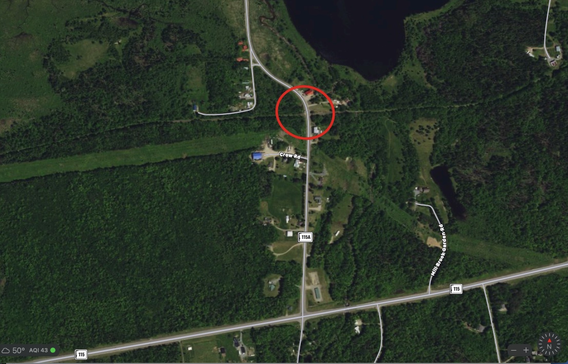
Because of Thursday's storm, we will start at the parking lot on 115A and complete the Pondicherry section first. Then we will ride to Israel River Road and continue on Valley Road to Jefferson Notch Road. The views of the Presidential Range on Valley Road are spectacular. When we reach Jefferson Notch Road, we can check the trail conditions.  If the snow has melted enough, we can continue to the Israel River Bridge. If not, we can take our lunch break near there and then head back to the parking area. Total distance will be around 19 miles.

To get to the parking area on 115A (also known as Meadows Road), take 302 towards Twin Mountain. Turn right at the Intersection of Route 3. Then another right onto 115. Continue on until you see 115A - there is a sign there and turn left. The parking lot will be on the left.

The above  update has been added to the MWV Bicycling Club website Ride Guide as well! 

 Hope to see you there! 😊🚲


Wow...Even more info.... With stunning photos!!

Saturday, April 24th - 10:00


Our route will start on the Presidential Rail Trail in the Pondicherry National Wildlife Refuge at Cherry Pond. We will then head out for the Presidential Views out on Valley Road.

Today, in Pondicherry:


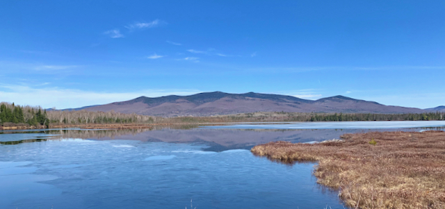
Looking across Cherry Pond


The Trail with views of the Presidential Range


Along the way, we will go by the Israel River Bridge which was built in 1917 and refitted last Fall with new abutments. We will see a number of "beaver deceivers" and pass by a dog sled business - you don't see (or hear) that everyday! On the way back, we will route over to a paved back road and connect to Valley Way. Besides a smoother surface, there are great views of the Presidential Range. 

The ride is definitely suited for gravel bikes or mountain bikes. We rode the trail last week and there are some muddy spots. The 4 mile section of the trail in Pondicherry is in great shape and the route has minimal elevation gain. 

Looking ahead at the weather, Saturday looks good with temperatures in the low 50's. However, there is some precipitation in the forecast for mid-week. We will ride the trail on Thursday and post an updated trail condition report. We may move the start to the Pondicherry parking lot on Meadows Road. We want this to be a fun day so please check back on Friday to verify the start.